- Home
- Your Government
- Departments
- Sustainability and Resilience
- Flood Management
Flood Management
Understanding the FEMA lingo
- Special Flood Hazard Areas (SFHAs): These are zones identified by FEMA as having a 1% annual chance of flooding. Properties within SFHAs are at higher risk for flooding, will have floodplain management regulations enforced and is where the mandatory purchase of flood insurance is required.
- SFHAs are shown on the FIRMs as Floodway, A, AE, X by Levee, and X within the City of Russellville, there are other designations of floodplain such as AO, C, V, A2, etc...
- Flood Insurance Rate Maps (FIRMs): FIRMs delineate flood zones and are essential tools for identifying flood-prone areas.
- Base Flood Elevation (BFE): The computed elevation to which floodwater is anticipated to rise during a base flood. Understanding your property's BFE is vital for construction and insurance purposes.
- Floodplain Administrator: The cities designated official that assists with flood zone determinations, permit requirements, and general inquiries.
- Permit Requirements: Any development within a floodplain requires a “Floodplain Development Permit” to ensure compliance with safety standards.
- Elevation Certificates: These documents certify a building's elevation relative to the BFE and are often required for insurance purposes.
Floodplain Management
Flooding poses a significant risk to communities across Arkansas, including Russellville. Understanding flood risks, implementing protective measures, and staying informed are crucial steps in safeguarding lives and property. The City of Russellville administers the oversight of floodplain regulations and the issuance of floodplain development permits for excavation and construction within the floodplain as outlined in the National Flood Insurance Program (NFIP) Flood Insurance Rate Maps (FIRMs). This website should provide you with essential information on floodplain management, resources available to residents, and actions you can take to mitigate flood risks. By staying informed and proactive, you can significantly reduce your risks associated with flooding. This serves as a starting point for understanding and engaging with floodplain management practices in our community.
Knowing the Local Flood Hazard
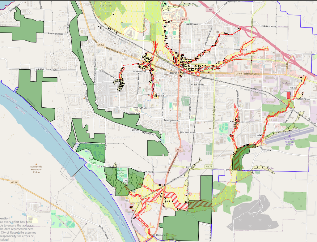
Understanding local flood risks is essential for making informed decisions about property, safety, and development in the City of Russellville. Russellville is subject to several flood hazards due to its location near significant water bodies and varying terrain.
Primary Bodies of Water: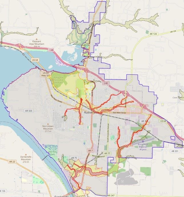
- Arkansas River – A major waterway that runs along the southern edge of the city, regulated by the Dardanelle Lock and Dam.
- Illinois Bayou – Flows through the northern portion of Russellville and has historically contributed to localized flooding.
- Lake Dardanelle – Formed by the Arkansas River, it serves as both a recreational resource and a flood control reservoir.
- Prairie Creek and Tributaries – Smaller streams running through the middle of town that drain to the US Army Corp of Engineers SUMP area, that can flood during intense rainfall events, especially in developed areas with limited stormwater capacity.
- Whig Creek and Tributaries – Another smaller stream running by the High School and Airport draining directly into the Arkansas River and can sometimes be impacted by flooding on the River.
Hazard Descriptions:
- Riverine Flooding: Caused by prolonged rainfall or upstream release of water from the Arkansas River and Lake Dardanelle. This type of flooding may result in rising waters over hours or days.
- Flash Flooding: Occurs in low-lying urban areas, especially near Illinois Bayou and Prairie Creek, during heavy rainfall. These floods are rapid and potentially dangerous, often occurring with little warning.
- Localized Urban Flooding: In areas with poor drainage infrastructure or significant impervious surfaces, heavy rains can overwhelm stormwater systems, leading to Temporary Street and property flooding.
History of Flood Events in Russellville:
- 1982 Flood: A major flood event along Illinois Bayou caused widespread damage and prompted floodplain revisions in affected areas.
- 2008 Flash Floods: Heavy rainfall caused flash flooding throughout central Russellville, impacting several homes and roadways.
- The Great Flood of 2019: Caused by major rain and flooding upstream along the Arkansas River, caused flooding downstream of the Dardanelle Dam that ran at maximum capacity for days. Impacted areas were along Whig Creek in the low lying areas with some impacts to the Arkansas River Bridge connecting Russellville to the City of Dardanelle.
- Ongoing Minor Flooding: Periodic Street and yard flooding continue to be reported during heavy rainstorms, particularly in older neighborhoods with aging infrastructure.
 Importance of Floodplain Management
Effective floodplain management is critical to the safety, sustainability, and resilience of our community. It:
- Protects Lives and Property: By guiding responsible development and land use in flood-prone areas, floodplain management reduces the risk of injury, loss of life, and costly property damage during flood events.
- Maintains Natural Floodplain Functions: Healthy floodplains absorb excess rain and runoff, reduce downstream flooding, recharge groundwater, and provide important wildlife habitat.
- Studies suggest that the Eastern Black Rail, the Piping Plover, the Red Knot, and the Missouri Bladderpod all considered threatened may be located within Russellville.
- Habitat loss poses a significant threat to these species and is primarily due to filling in wetland areas for new development for commercial and residential structures.
- Pollution and the spread of invasive species are also factors in habitat loss.
- Conservation efforts including habitat preservation and restoration are imperative in assisting maintenance of the natural floodplain functions.
- Supports Economic Stability: Preventing flood damage helps protect local infrastructure, businesses, and homes, reducing economic disruptions and supporting long-term community growth.
- Ensures Compliance with Federal and Local Regulations: Following National Flood Insurance Program (NFIP) standards and local ordinances helps communities stay in good standing and reduces legal or financial risks.
- Improves Access to Flood Insurance Discounts: Participation in programs like FEMA’s Community Rating System (CRS) can provide reduced flood insurance premiums for residents, rewarding proactive floodplain management.
- Cities Current CRS Level: Class 10 – 0% Discount.
- Current Initiative: Application is in process working towards a class 9 – 5% Discount for initial approval with a goal of reaching a Class 6 – 20% Discount on flood insurance.
- Promotes Informed Decision-Making: Collecting and sharing accurate flood data helps residents, developers, and officials make smart, forward-looking choices about building and investing in the community.
 Floodplain Development Permit Required
Permits are required to help preserve the natural functions of floodplains, which are vital for flood mitigation, water quality, and wildlife habitat. Before initiating any development within designated floodplain areas, a Floodplain Development Permit must be obtained. This permit process ensures that proposed developments comply with local and federal floodplain management standards, minimizing flood risks and protecting public safety and property. Applicants must submit detailed plans that demonstrate compliance with elevation requirements and flood mitigation measures. The City's review process evaluates potential impacts on the floodplain to ensure that proposed development will not increase flood hazards for surrounding properties.
Floodplain Development Permit Form
Substantial Improvement / Substantial Damage Requirements
Russellville follows FEMA’s National Flood Insurance Program (NFIP) guidelines for determining substantial improvement and substantial damage within floodplain areas:
- Substantial Improvement: Any reconstruction, rehabilitation, addition, or other improvement to a structure where the cost equals or exceeds 50% of the building’s market value prior to the improvement.
- Substantial Damage: Damage of any origin where the cost to repair the structure to its pre-damage condition equals or exceeds 50% of the structure’s market value before the damage occurred.
In both cases, structures must be brought into compliance with current floodplain regulations. This may include elevating the building to or above the base flood elevation (BFE), using flood-resistant materials, and ensuring utility systems are elevated or floodproofed. All additions must comply with current floodplain regulations and building codes, regardless of whether the specified thresholds are met.
Flood Insurance Information
- National Flood Insurance Program (NFIP): Managed by FEMA, the NFIP offers federally backed flood insurance to property owners, renters, and businesses. Participation in the NFIP supports community-wide resilience and eligibility for disaster assistance.
- Participation by the City: The City participates in the NFIP making this federally backed flood insurance available to anyone living in the community, regardless of physically being located within a Special Flood Hazard Area.
- Participation by the City: The City participates in the NFIP making this federally backed flood insurance available to anyone living in the community, regardless of physically being located within a Special Flood Hazard Area.
- Insurance Requirements: Properties located in Special Flood Hazard Areas (SFHAs) with federally backed mortgages are required by law to carry flood insurance.
- Standard homeowners insurance does not cover flood damage. A separate flood insurance policy is necessary to protect against losses from rising water.
- Flood insurance policies can be purchased through the NFIP or private insurers and cover building and/or contents, depending on the policy.
- 30-Day Waiting Period. There is a 30-day waiting period prior to coverage being available for your property. Pre-planning is imperative.
- Flood coverage must be maintained for the life of the loan to comply with federal regulations and avoid penalties or uninsured losses.
- Policy Details: Understanding what your flood insurance covers—including coverage limits, exclusions (such as basements or detached structures), and the claims process—ensures you are prepared and adequately protected in the event of a flood.
Flood Safety and Preparedness
Flooding can happen quickly and without warning. Knowing how to prepare before, during, and after a flood is critical for protecting lives and reducing damage to property in the City of Russellville.
Stay Informed
- Monitor Weather Alerts: Tune in to local news, NOAA Weather Radio, or apps for emergency alerts and flood warnings.
- River and Bayou Levels: Keep an eye on the Arkansas River gauge at Dardanelle Dam to track water levels in real-time.
- Warning Signals: Intense and prolonged rain, rising water levels in streams and rivers, and debris or murky water may all be signs that flooding is imminent.
Emergency Preparedness Plans
- City of Russellville Emergency Response Plan – under development.
- Pope County Hazard Mitigation Plan – Hazard Mitigation Plan .
- Evacuation Routes: Identify and review flood evacuation routes for your neighborhood. Avoid driving or walking through floodwaters and avoid the following areas that typically flood:
- Phoenix Avenue – Between N Arkansas and West Parkway drive along the US Army Corp of Engineers Sump area.
- N Arkansas – At the intersection of O Street at the entrance to ATU.
- Parkway Drive – Between N Arkansas and El Paso.
- Intersection of Weir and Parkway – Historically has been impacted by flooding. A stormwater improvement project completed in 2020 that seems to have resolved flooding in this area.
- Vancouver and 3rd – Has historically seen flooding, however the Waco Pond Improvements have drastically reduced flooding in this area.
- Household Emergency Plan:
- Designate a meeting place and emergency contact outside the flood area.
- Prepare a “Go Bag” with essentials such as medications, identification, and important documents.
Protecting People and Property
- Before a Flood:
- Elevate major appliances, electrical panels, and HVAC systems above Base Flood Elevation (BFE).
- Install sump pumps with battery backup.
- Use flood-resistant materials in renovations or new construction.
- Anchor fuel tanks and protect wells from contamination.
- During a Flood Event:
- Turn off electricity, gas, and water at the main switch or valve if instructed to evacuate.
- Move valuables and important papers to higher ground or upper floors.
- Follow emergency instructions immediately and avoid floodwaters.
- After a Flood:
- Do not enter flooded buildings until inspected for structural safety.
- Watch for mold, gas leaks, and other hazards before cleanup.
- Document damage thoroughly for insurance and FEMA claims, pictures of damage and high-water marks are extremely valuable.
Reporting Issues and Supporting Prevention
- Illegal Dumping and Drainage Blockages: Call the City of Russellville Public Works Department or Code Enforcement at 479-968-2406 to report dumping or obstructions in ditches, creeks, or storm drains. Keeping waterways clear helps reduce flood risk for the whole community.
- Blocked Drainage Inlets: If you notice clogged inlets or manholes before or during a storm, report them promptly to Public Works at 479-968-2406.
Wind, Severe Storm, and Tornado Considerations
- While Russellville is inland, wind damage from remnants of tropical systems can still occur along with high wind events due to tornadoes or storms moving across the Midwest.
- Trim dead or weak trees and branches.
- Secure loose outdoor items.
- Reinforce doors and windows, especially on older homes.
Emergency Floodproofing Measures
If a flood is imminent and there is little time to prepare, consider these temporary steps:
- Use sandbags or commercial flood barriers at entryways.
- Install plastic sheeting or waterproof panels to seal doors and window wells.
- Relocate valuables to upper stories.
- Place important electronics and documents in waterproof containers.
Floodplain Information Services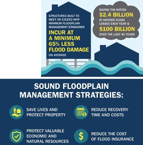
As a public service, the City of Russellville provides the following floodplain-related information upon request:
- Confirmation of whether a specific property is located within the Special Flood Hazard Area (SFHA), as shown on the most current Flood Insurance Rate Map (FIRM) for Russellville.
- Additional flood insurance data for a property, including the FIRM zone designation and, if available, base flood elevation (BFE) or flood depth.
- A helpful handout outlining the flood insurance purchase requirements, particularly useful for individuals seeking a mortgage or loan for properties located in the SFHA.
- Access to elevation certificates for recently constructed structures within the city.
- Guidance and assistance in using the City of Russellville’s public GIS mapping system to view floodplain data and property information.
To request this information, please provide the property’s street address and, if known, the subdivision name, lot, and block number.